 Altădată
Existing church · 1705
Scaune Church
Scaune Church, dedicated to the Dormition and the Nativity of the Mother of God, takes its name from the Scaune neighborhood, where butchers cut meat on wooden blocks (scaune); in its early centuries it was also called the Butchers' or the Soap-Makers' church. The inscription mentions a wooden church in 1611, and the masonry one was completed in 1705, with money left by a merchant. Having fallen into ruin, it stayed closed for almost three decades after 1908; restored under the direction of the architect Ștefan Balș-Lupu, it was reopened in 1944. It preserves its original frescoes, by an unknown painter, and an early 18th-century iconostasis.
See the place on the old maps ›Text source: en.wikipedia.org · summary based on the source
Old photographs
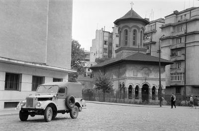
Strada Slănic - Strada Scaune sarok, szemben a Biserica Scaune
1962 · FORTEPAN / Gazda Anikó · CC BY-SA 3.0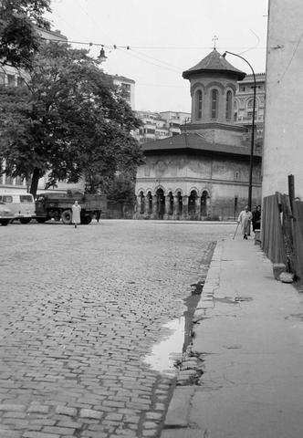
Strada Slănic, szemben a Biserica Scaune
1962 · FORTEPAN / Gazda Anikó · CC BY-SA 3.0
On the old maps
The place appears on 45 maps and images, from 1790 to today:
- 1790 · Specht Plan
- 1791 · Ernst Plan
- 1846 · Borroczyn Plan
- 1852 · Borroczyn Plan
- 1864 · Szathmari Plan
- 1871 · Pappasoglu Plan
- 1883 · Cerkez Plan
- 1893 · Orăscu Plan
- 1896 · J. Don Plan
- 1900 · Plan of Bucharest 1900
- 1911 · Army Geographic Institute Plan
- 1914 · Socec Plan
- 1921 · Mihai Pantea Plan
- 1926 · Union Plan
- 1927 · Aerial photo 1927
- 1927 · Socec Plan
- 1928 · Industrial Plan
- 1931 · STB Plan
- 1931 · Unirea Plan
- 1934 · Wahing Plan
- 1938 · Aerial photo 1938
- 1938 · Teodorescu Plan
- 1939 · Simboteanu and Moldoveanu Plan
- ~1940 · Artillery Firing Plans
- 1943 · Aerial photo 1943
- 1962 · Cadastral Plan (center)
- 1966 · Satellite image 1966
- 1968 · Map of Bucharest 1968
- 1969 · Map of Bucharest 1969
- 1972 · Satellite image 1972
- 1974 · Cadastral Plan (center)
- 1976 · Satellite image 1976
- 1977 · Satellite image 1977
- 1978 · Satellite image 1978
- 1979 · Satellite image 1979
- 1980 · Satellite image 1980
- 1982 · Satellite image 1982
- 1982 · ITB Plan
- 1983 · Satellite image 1983
- 1984 · Satellite image 1984
- ~1985 · Soviet Topographic Map
- 1990 · Cadastral Plan
- 2001 · AGC Polonia Plan
- 2017 · Orthophoto 2017
- today · Current satellite
Nearby
- Astra Română Company Building · 90 m
- Ministry of Agriculture Palace · 100 m
- Monument to C. A. Rosetti · 140 m
- Colțea Church · 180 m
- Statue of Spătar Mihai Cantacuzino · 210 m
- Church with Saints · 240 m