 Altădată
Existing church · 1904–1907
St. Sylvester Church
In the Silvestru neighborhood, Master Pârvu the dyer and his wife Stanca built a church in 1743, which was damaged by the 1802 earthquake and brought down by that of 1838, then rebuilt and consecrated in 1839. The present, much enlarged church was built between 1904 and 1907 to a design by the architect Paul Petricu, with two twisted towers over the pronaos, modeled on Curtea de Argeș, and Neo-Byzantine murals by Costin Petrescu. The bell tower, dated 1879, has a passage beneath it through which Oltarului Street runs. Father Constantin Galeriu served here between 1974 and 2003.
See the place on the old maps ›Text source: ro.wikipedia.org · summary based on the source
Old photographs

Biserica Sfântul Silvestru din Bucureşti
1910 · Leopold Adler · Public domain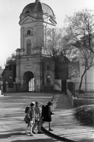
Strada Silvestru, az ortodox Szent Szilveszter-templom (Biserica Sfântul Silvestru) harangtornya
1952 · FORTEPAN / Dőri fotó Kolozsvár · CC BY-SA 3.0

On the old maps
The place appears on 44 maps and images, from 1790 to today:
- 1790 · Specht Plan
- 1791 · Ernst Plan
- 1846 · Borroczyn Plan
- 1852 · Borroczyn Plan
- 1864 · Szathmari Plan
- 1871 · Pappasoglu Plan
- 1883 · Cerkez Plan
- 1893 · Orăscu Plan
- 1896 · J. Don Plan
- 1900 · Plan of Bucharest 1900
- 1911 · Army Geographic Institute Plan
- 1914 · Socec Plan
- 1921 · Mihai Pantea Plan
- 1926 · Union Plan
- 1927 · Aerial photo 1927
- 1927 · Socec Plan
- 1928 · Industrial Plan
- 1931 · STB Plan
- 1931 · Unirea Plan
- 1934 · Wahing Plan
- 1938 · Aerial photo 1938
- 1938 · Teodorescu Plan
- 1939 · Simboteanu and Moldoveanu Plan
- ~1940 · Artillery Firing Plans
- 1943 · Aerial photo 1943
- 1966 · Satellite image 1966
- 1968 · Map of Bucharest 1968
- 1969 · Map of Bucharest 1969
- 1972 · Satellite image 1972
- 1974 · Cadastral Plan (center)
- 1976 · Satellite image 1976
- 1977 · Satellite image 1977
- 1978 · Satellite image 1978
- 1979 · Satellite image 1979
- 1980 · Satellite image 1980
- 1982 · Satellite image 1982
- 1982 · ITB Plan
- 1983 · Satellite image 1983
- 1984 · Satellite image 1984
- ~1985 · Soviet Topographic Map
- 1990 · Cadastral Plan
- 2001 · AGC Polonia Plan
- 2017 · Orthophoto 2017
- today · Current satellite
Nearby
- Monument to the Heroes of 1916–1918 (Silvestru) · 50 m
- Bust of Professor Vasile Șuteu · 320 m
- Popa Chițu Church (Popa Petre) · 330 m
- Monument to Tudor Vladimirescu · 370 m
- Precupeții Vechi Church · 390 m
- Statue of Theodor Pallady · 420 m