 Altădată
Historic building · înc. sec. al XIX-lea (casa); muzeu din anii 1950
Gheorghe Tattarescu Memorial Museum
The Gheorghe Tattarescu Memorial Museum occupies the house on Domnița Anastasia Street where the painter lived and worked for four decades. The house, built at the beginning of the 19th century on the old Belvedere lane, was bought by Tattarescu in 1855, and by 1858 the artist had added rooms and a studio, where he also received his students. Tattarescu (1820–1894), who painted the interiors of many Bucharest churches, founded the School of Fine Arts in Bucharest together with Theodor Aman. The house was donated to the state by the painter's granddaughter in the 1950s.
See the place on the old maps ›Text source: ro.wikipedia.org · summary based on the source
Old photographs

Muzeul Gheorghe Tattarescu - Curtea
1894 · Public domain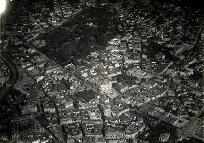
Centrul Bucureștiului din avion: Cișmigiu, Palatul CEC și Dâmbovița
1938 · Luftwaffe · U.S. National Archives, scanare John Calvin · Domeniu public


On the old maps
The place appears on 45 maps and images, from 1790 to today:
- 1790 · Specht Plan
- 1791 · Ernst Plan
- 1846 · Borroczyn Plan
- 1852 · Borroczyn Plan
- 1864 · Szathmari Plan
- 1871 · Pappasoglu Plan
- 1883 · Cerkez Plan
- 1893 · Orăscu Plan
- 1896 · J. Don Plan
- 1900 · Plan of Bucharest 1900
- 1911 · Army Geographic Institute Plan
- 1914 · Socec Plan
- 1921 · Mihai Pantea Plan
- 1926 · Union Plan
- 1927 · Aerial photo 1927
- 1927 · Socec Plan
- 1928 · Industrial Plan
- 1931 · STB Plan
- 1931 · Unirea Plan
- 1934 · Wahing Plan
- 1938 · Aerial photo 1938
- 1938 · Teodorescu Plan
- 1939 · Simboteanu and Moldoveanu Plan
- ~1940 · Artillery Firing Plans
- 1943 · Aerial photo 1943
- 1962 · Cadastral Plan (center)
- 1966 · Satellite image 1966
- 1968 · Map of Bucharest 1968
- 1969 · Map of Bucharest 1969
- 1972 · Satellite image 1972
- 1974 · Cadastral Plan (center)
- 1976 · Satellite image 1976
- 1977 · Satellite image 1977
- 1978 · Satellite image 1978
- 1979 · Satellite image 1979
- 1980 · Satellite image 1980
- 1982 · Satellite image 1982
- 1982 · ITB Plan
- 1983 · Satellite image 1983
- 1984 · Satellite image 1984
- ~1985 · Soviet Topographic Map
- 1990 · Cadastral Plan
- 2001 · AGC Polonia Plan
- 2017 · Orthophoto 2017
- today · Current satellite
Nearby
- Vama Poștei Palace · 120 m
- St. John the Great Monastery · 200 m
- National Military Circle Palace · 200 m
- Sărindar Monastery · 230 m
- Marmorosch Blank Bank Palace · 240 m
- Zlătari Church · 250 m