 Altădată
Historic building · 1937–1952
Victoria Palace
Victoria Palace, the seat of the Romanian Government, was designed by the architect Duiliu Marcu for the Ministry of Foreign Affairs; construction began in 1937 and was completed in 1944. Damaged by the 1944 bombings, it was rebuilt, the work being finished in 1952. In the communist period it housed the Ministry of Foreign Affairs and the Council of Ministers, and since 1990 it has housed the government of post-communist Romania. The building in Piața Victoriei was included in the List of Historic Monuments in 2004.
See the place on the old maps ›Text source: ro.wikipedia.org · summary based on the source
Old photographs

Interwar or WW2 photo of the Victoria Palace (left) and the Sturdza Palace (right) in…
1944 · Neoclassicism Enthusiast · Public domain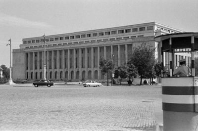
Piața Victoriei, szemben a Palatul Victoria (kormányzati épület)
1965 · FORTEPAN / Bojár Sándor · CC BY-SA 3.0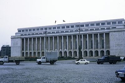
Piața Victoriei, szemben a Palatul Victoria (kormányzati épület)
1970 · FORTEPAN / UWM Libraries · CC BY-SA 3.0

On the old maps
The place appears on 43 maps and images, from 1790 to today:
- 1790 · Specht Plan
- 1791 · Ernst Plan
- 1846 · Borroczyn Plan
- 1852 · Borroczyn Plan
- 1864 · Szathmari Plan
- 1871 · Pappasoglu Plan
- 1883 · Cerkez Plan
- 1893 · Orăscu Plan
- 1896 · J. Don Plan
- 1900 · Plan of Bucharest 1900
- 1911 · Army Geographic Institute Plan
- 1914 · Socec Plan
- 1921 · Mihai Pantea Plan
- 1926 · Union Plan
- 1927 · Socec Plan
- 1928 · Industrial Plan
- 1931 · STB Plan
- 1931 · Unirea Plan
- 1934 · Wahing Plan
- 1938 · Aerial photo 1938
- 1938 · Teodorescu Plan
- 1939 · Simboteanu and Moldoveanu Plan
- ~1940 · Artillery Firing Plans
- 1943 · Aerial photo 1943
- 1966 · Satellite image 1966
- 1968 · Map of Bucharest 1968
- 1969 · Map of Bucharest 1969
- 1972 · Satellite image 1972
- 1974 · Cadastral Plan (center)
- 1976 · Satellite image 1976
- 1977 · Satellite image 1977
- 1978 · Satellite image 1978
- 1979 · Satellite image 1979
- 1980 · Satellite image 1980
- 1982 · Satellite image 1982
- 1982 · ITB Plan
- 1983 · Satellite image 1983
- 1984 · Satellite image 1984
- ~1985 · Soviet Topographic Map
- 1990 · Cadastral Plan
- 2001 · AGC Polonia Plan
- 2017 · Orthophoto 2017
- today · Current satellite
Nearby
- Oromolu House · 120 m
- National Museum of Geology · 260 m
- Manu-Auschnitt House · 330 m
- National Museum of the Romanian Peasant · 330 m
- Mavrogheni Church · 410 m
- Cantacuzino Palace · 470 m