 Altădată
Historic building · 1886–1888
Romanian Athenaeum
The Romanian Athenaeum, the concert hall on Calea Victoriei, was built in 1886–1888 to a design by the French architect Albert Galleron, recommended by Charles Garnier, on land that had belonged to the Văcărescu family; part of the money was raised through the public subscription “Dați un leu pentru Ateneu” (“Give a leu for the Athenaeum”). The circular building, with a large dome and a façade in the form of an Ionic temple, opened on 14 February 1888, although work continued until 1897. In December 1919 the union of Bessarabia, Transylvania and Bukovina with the Old Kingdom was ratified here. It is the home of the “George Enescu” Philharmonic.
See the place on the old maps ›Text source: ro.wikipedia.org · summary based on the source
Old photographs
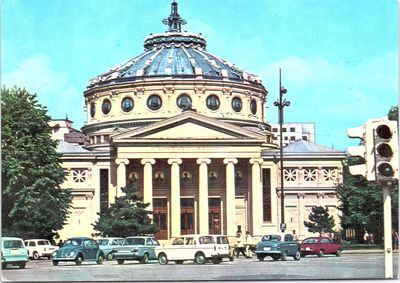
Ateneul Român
1800 · Institutul Național al Patrimoniului, colecția Andrei Ștomff · CC BY-SA 4.0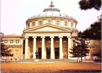
Ateneul Român
1800 · Institutul Național al Patrimoniului, colecția Andrei Ștomff · CC BY-SA 4.0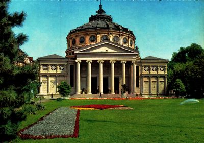
Atheneul R. P. Române
1800 · Institutul Național al Patrimoniului, colecția Andrei Ștomff · CC BY-SA 4.0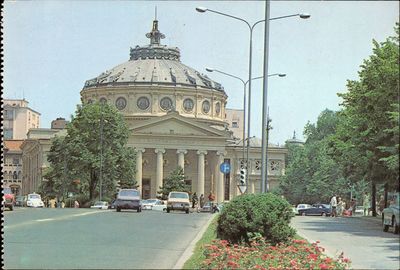
România. București. Romanian Athenaeum
1800 · Institutul Național al Patrimoniului, colecția Andrei Ștomff · CC BY-SA 4.0
Romanian Athenaeum in Bucharest Romania
1940 · Public domain
Blick auf Athenäum und Fund. Carol I. vom Balkon des Schlosses
1942 · Willy Pragher · CC BY 4.0


On the old maps
The place appears on 44 maps and images, from 1790 to today:
- 1790 · Specht Plan
- 1791 · Ernst Plan
- 1846 · Borroczyn Plan
- 1852 · Borroczyn Plan
- 1864 · Szathmari Plan
- 1871 · Pappasoglu Plan
- 1883 · Cerkez Plan
- 1893 · Orăscu Plan
- 1896 · J. Don Plan
- 1900 · Plan of Bucharest 1900
- 1911 · Army Geographic Institute Plan
- 1914 · Socec Plan
- 1921 · Mihai Pantea Plan
- 1926 · Union Plan
- 1927 · Aerial photo 1927
- 1927 · Socec Plan
- 1928 · Industrial Plan
- 1931 · STB Plan
- 1931 · Unirea Plan
- 1934 · Wahing Plan
- 1938 · Aerial photo 1938
- 1938 · Teodorescu Plan
- 1939 · Simboteanu and Moldoveanu Plan
- ~1940 · Artillery Firing Plans
- 1943 · Aerial photo 1943
- 1966 · Satellite image 1966
- 1968 · Map of Bucharest 1968
- 1969 · Map of Bucharest 1969
- 1972 · Satellite image 1972
- 1974 · Cadastral Plan (center)
- 1976 · Satellite image 1976
- 1977 · Satellite image 1977
- 1978 · Satellite image 1978
- 1979 · Satellite image 1979
- 1980 · Satellite image 1980
- 1982 · Satellite image 1982
- 1982 · ITB Plan
- 1983 · Satellite image 1983
- 1984 · Satellite image 1984
- ~1985 · Soviet Topographic Map
- 1990 · Cadastral Plan
- 2001 · AGC Polonia Plan
- 2017 · Orthophoto 2017
- today · Current satellite
Nearby
- Episcopiei Church (metochion of the Bishopric of Râmnic) · 90 m
- Theodor Aman Museum · 140 m
- Boteanu Church · 180 m
- Ciclop Garage · 180 m
- White Church · 220 m
- Dimitrie Sturdza House · 240 m