 Altădată
Existing church · 1679–1682 (demolată 1984, refăcută 2003–2009)
Cotroceni Monastery
Cotroceni Monastery was founded by Șerban Cantacuzino, who, according to tradition, vowed to build a church after hiding here from the persecution of Duca Vodă; once he became prince, he began construction on 26 May 1679 and finished it in 1682. The church, with murals by Pârvu Mutu, housed the founder's tomb, and the princely houses in the precinct served as his residence. Closed to worship in 1948 and left in ruins, it was demolished in 1984 on Ceaușescu's orders, but the architect Camil Roguski saved the carved stonework and the frescoes. The church was rebuilt in 2003–2009 and reconsecrated in 2009.
See the place on the old maps ›Text source: ro.wikipedia.org · summary based on the source
Old photographs

Palatul Cotroceni
1902 · Alexandru Antoniu · Public domain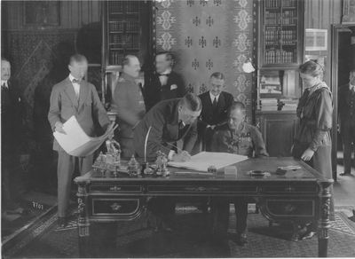
Semnarea Păcii de la București, 7 mai 1918: Richard von Kühlmann semnează, alături de contele Czernin
1918 · fotografie oficială germană · U.S. National Archives, 165-GB-07707 · Domeniu public

On the old maps
The place appears on 43 maps and images, from 1790 to today:
- 1790 · Specht Plan
- 1791 · Ernst Plan
- 1846 · Borroczyn Plan
- 1852 · Borroczyn Plan
- 1864 · Szathmari Plan
- 1871 · Pappasoglu Plan
- 1883 · Cerkez Plan
- 1893 · Orăscu Plan
- 1896 · J. Don Plan
- 1900 · Plan of Bucharest 1900
- 1911 · Army Geographic Institute Plan
- 1914 · Socec Plan
- 1921 · Mihai Pantea Plan
- 1926 · Union Plan
- 1927 · Aerial photo 1927
- 1927 · Socec Plan
- 1928 · Industrial Plan
- 1931 · STB Plan
- 1931 · Unirea Plan
- 1934 · Wahing Plan
- 1938 · Aerial photo 1938
- 1938 · Teodorescu Plan
- 1939 · Simboteanu and Moldoveanu Plan
- ~1940 · Artillery Firing Plans
- 1943 · Aerial photo 1943
- 1966 · Satellite image 1966
- 1968 · Map of Bucharest 1968
- 1969 · Map of Bucharest 1969
- 1972 · Satellite image 1972
- 1976 · Satellite image 1976
- 1977 · Satellite image 1977
- 1978 · Satellite image 1978
- 1979 · Satellite image 1979
- 1980 · Satellite image 1980
- 1982 · Satellite image 1982
- 1982 · ITB Plan
- 1983 · Satellite image 1983
- 1984 · Satellite image 1984
- ~1985 · Soviet Topographic Map
- 1990 · Cadastral Plan
- 2001 · AGC Polonia Plan
- 2017 · Orthophoto 2017
- today · Current satellite
Nearby
- Monument to the Engineer Heroes (The Lion) · 260 m
- Monument to Ana Davila · 270 m
- St. Elizabeth Chapel · 300 m
- Bust of Panait Donici · 360 m
- Monument to the Heroes of the Fatherland · 550 m
- Statue of Carol Davila · 600 m