 Altădată
Existing church · 1702
St. Nicholas Dintr-o Zi Church
The church's name (“from a single day”) comes from a local tradition according to which the first small wooden church on this site was built in a single day. The dedicatory inscription shows that, once the wooden church had grown old, Lady Marica, Constantin Brâncoveanu's wife, rebuilt it in masonry in 1702, with the works overseen by the Grand Logothete Enache Văcărescu. Damaged by a fire in 1825, the church was renovated with the support of Prince Grigore IV Ghica and of the churchwarden Stanciu, the works being completed on 1 September 1827. It is dedicated to St. Nicholas and is a historic monument.
See the place on the old maps ›Text source: ro.wikipedia.org · summary based on the source
Old photographs

Dintr-o Zi Church
1856 · Ludwig Angerer · Public domain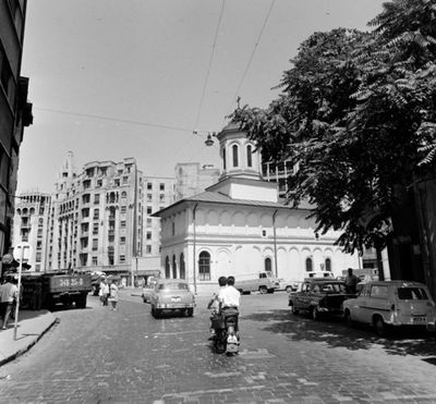
Strada Academiei, előtérben jobbra az Szent Miklós-templom / "Egy nap alatt" (Biserica Sfantul Nicolae / "Dint
1965 · FORTEPAN / Bojár Sándor · CC BY-SA 3.0

On the old maps
The place appears on 45 maps and images, from 1790 to today:
- 1790 · Specht Plan
- 1791 · Ernst Plan
- 1846 · Borroczyn Plan
- 1852 · Borroczyn Plan
- 1864 · Szathmari Plan
- 1871 · Pappasoglu Plan
- 1883 · Cerkez Plan
- 1893 · Orăscu Plan
- 1896 · J. Don Plan
- 1900 · Plan of Bucharest 1900
- 1911 · Army Geographic Institute Plan
- 1914 · Socec Plan
- 1921 · Mihai Pantea Plan
- 1926 · Union Plan
- 1927 · Aerial photo 1927
- 1927 · Socec Plan
- 1928 · Industrial Plan
- 1931 · STB Plan
- 1931 · Unirea Plan
- 1934 · Wahing Plan
- 1938 · Aerial photo 1938
- 1938 · Teodorescu Plan
- 1939 · Simboteanu and Moldoveanu Plan
- ~1940 · Artillery Firing Plans
- 1943 · Aerial photo 1943
- 1962 · Cadastral Plan (center)
- 1966 · Satellite image 1966
- 1968 · Map of Bucharest 1968
- 1969 · Map of Bucharest 1969
- 1972 · Satellite image 1972
- 1974 · Cadastral Plan (center)
- 1976 · Satellite image 1976
- 1977 · Satellite image 1977
- 1978 · Satellite image 1978
- 1979 · Satellite image 1979
- 1980 · Satellite image 1980
- 1982 · Satellite image 1982
- 1982 · ITB Plan
- 1983 · Satellite image 1983
- 1984 · Satellite image 1984
- ~1985 · Soviet Topographic Map
- 1990 · Cadastral Plan
- 2001 · AGC Polonia Plan
- 2017 · Orthophoto 2017
- today · Current satellite
Nearby
- Ion Mincu Institute of Architecture Palace · 90 m
- Enei Church · 120 m
- Telephone Palace · 160 m
- Capșa House · 170 m
- University Palace · 210 m
- Statue of Spiru Haret · 210 m