 Altădată
Historic building · 1929–1934
Telephone Palace
The Telephone Palace was built on Calea Victoriei on the site of the houses of the boyar Oteteleșanu, where the famous terrace of the same name, a meeting place for high society, had operated. Designed by Edmond van Saanen Algi together with American architects, in the spirit of Art Deco skyscrapers, it was the first tall building in the country with a steel structure and was inaugurated in 1934. At 52.5 m, it remained the tallest building in Bucharest until 1956. Affected by the 1944 bombings and by the earthquakes of 1940, 1977, 1986 and 1990, it underwent ten years of consolidation work beginning in 1995.
See the place on the old maps ›Text source: ro.wikipedia.org · summary based on the source
Old photographs
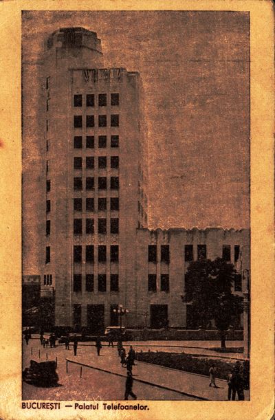
Palatul Telefoanelor
1900 · Institutul Național al Patrimoniului, colecția Andrei Ștomff · CC BY-SA 4.0
Telefonhaus – Palatul Telefoanelor
1935 · CC BY 4.0
Die leere Calea Victoriei an einem Kriegssonntag
1941 · Willy Pragher · CC BY 4.0
Fensterputzer am Telefonhaus, mit Weitwinkel
1941 · Willy Pragher · CC BY 4.0
Fensterputzer am Telefonhaus, von weit gesehen
1941 · Willy Pragher · CC BY 4.0
Zeitungsstand in der Passage, Hintergrund Telefonhaus
1941 · Willy Pragher · CC BY 4.0


On the old maps
The place appears on 45 maps and images, from 1790 to today:
- 1790 · Specht Plan
- 1791 · Ernst Plan
- 1846 · Borroczyn Plan
- 1852 · Borroczyn Plan
- 1864 · Szathmari Plan
- 1871 · Pappasoglu Plan
- 1883 · Cerkez Plan
- 1893 · Orăscu Plan
- 1896 · J. Don Plan
- 1900 · Plan of Bucharest 1900
- 1911 · Army Geographic Institute Plan
- 1914 · Socec Plan
- 1921 · Mihai Pantea Plan
- 1926 · Union Plan
- 1927 · Aerial photo 1927
- 1927 · Socec Plan
- 1928 · Industrial Plan
- 1931 · STB Plan
- 1931 · Unirea Plan
- 1934 · Wahing Plan
- 1938 · Aerial photo 1938
- 1938 · Teodorescu Plan
- 1939 · Simboteanu and Moldoveanu Plan
- ~1940 · Artillery Firing Plans
- 1943 · Aerial photo 1943
- 1962 · Cadastral Plan (center)
- 1966 · Satellite image 1966
- 1968 · Map of Bucharest 1968
- 1969 · Map of Bucharest 1969
- 1972 · Satellite image 1972
- 1974 · Cadastral Plan (center)
- 1976 · Satellite image 1976
- 1977 · Satellite image 1977
- 1978 · Satellite image 1978
- 1979 · Satellite image 1979
- 1980 · Satellite image 1980
- 1982 · Satellite image 1982
- 1982 · ITB Plan
- 1983 · Satellite image 1983
- 1984 · Satellite image 1984
- ~1985 · Soviet Topographic Map
- 1990 · Cadastral Plan
- 2001 · AGC Polonia Plan
- 2017 · Orthophoto 2017
- today · Current satellite
Nearby
- Capșa House · 90 m
- National Military Circle Palace · 140 m
- Sărindar Monastery · 150 m
- St. Nicholas Dintr-o Zi Church · 160 m
- Kretzulescu Church · 210 m
- St. Ionică Church (lost) · 210 m