 Altădată
Existing church · 1720–1722
Kretzulescu Church
Kretzulescu (Crețulescu) Church, on Calea Victoriei, was built in 1720–1722 by the Grand Logothete Iordache Crețulescu and his wife, Safta, one of Constantin Brâncoveanu's daughters. At the time, the city's northern barrier stood here, on Podul Mogoșoaiei, and the founder also built an inn next to the church. It has a trefoil plan, a slender tower over the nave, a bell tower over the pronaos and an open porch on stone columns; the interior murals are by Gheorghe Tattarescu (1859–1860). The 1935–1936 restoration left its brickwork exposed, and during the communist period it escaped demolition thanks to the intervention of a group of architects.
See the place on the old maps ›Text source: ro.wikipedia.org · summary based on the source
Old photographs

Portal der Kirche Cretulescu
1941 · Willy Pragher · CC BY 4.0
Portal der Kirche Cretulescu, Tafel näher
1941 · Willy Pragher · CC BY 4.0
Calea Victoriei 45. Kretzulescu templom
1957 · Fortepan / Gyöngyi · CC BY-SA 3.0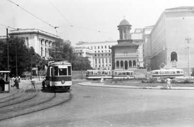
Strada Ion Câmpineanu (13 Decembrie), szemben a Kretzulescu-templom (Biserica Kretzulescu)
1958 · FORTEPAN / Közösségi Szociális Szövetkezet · CC BY-SA 3.0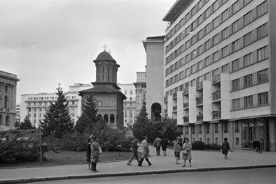
Strada Ion Câmpineanu (13 Decembrie), szemben a Kretzulescu-templom (Biserica Kretzulescu)
1962 · FORTEPAN / Chuckyeager tumblr · CC BY-SA 3.0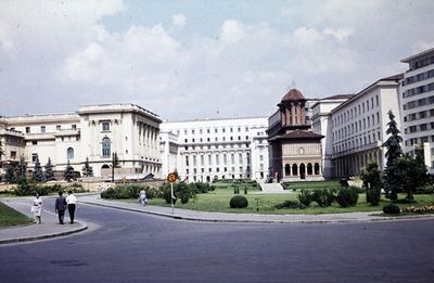
Strada Ion Câmpineanu (13 Decembrie), szemben a Kretzulescu-templom (Biserica Kretzulescu)
1963 · FORTEPAN / Pozsgay Eszter · CC BY-SA 3.0


On the old maps
The place appears on 45 maps and images, from 1790 to today:
- 1790 · Specht Plan
- 1791 · Ernst Plan
- 1846 · Borroczyn Plan
- 1852 · Borroczyn Plan
- 1864 · Szathmari Plan
- 1871 · Pappasoglu Plan
- 1883 · Cerkez Plan
- 1893 · Orăscu Plan
- 1896 · J. Don Plan
- 1900 · Plan of Bucharest 1900
- 1911 · Army Geographic Institute Plan
- 1914 · Socec Plan
- 1921 · Mihai Pantea Plan
- 1926 · Union Plan
- 1927 · Aerial photo 1927
- 1927 · Socec Plan
- 1928 · Industrial Plan
- 1931 · STB Plan
- 1931 · Unirea Plan
- 1934 · Wahing Plan
- 1938 · Aerial photo 1938
- 1938 · Teodorescu Plan
- 1939 · Simboteanu and Moldoveanu Plan
- ~1940 · Artillery Firing Plans
- 1943 · Aerial photo 1943
- 1962 · Cadastral Plan (center)
- 1966 · Satellite image 1966
- 1968 · Map of Bucharest 1968
- 1969 · Map of Bucharest 1969
- 1972 · Satellite image 1972
- 1974 · Cadastral Plan (center)
- 1976 · Satellite image 1976
- 1977 · Satellite image 1977
- 1978 · Satellite image 1978
- 1979 · Satellite image 1979
- 1980 · Satellite image 1980
- 1982 · Satellite image 1982
- 1982 · ITB Plan
- 1983 · Satellite image 1983
- 1984 · Satellite image 1984
- ~1985 · Soviet Topographic Map
- 1990 · Cadastral Plan
- 2001 · AGC Polonia Plan
- 2017 · Orthophoto 2017
- today · Current satellite
Nearby
- St. Ionică Church (lost) · 90 m
- Palace Hall · 160 m
- Brezoianu Church (lost) · 170 m
- Telephone Palace · 210 m
- Stejarul Church · 230 m
- Theodor Aman Museum · 270 m