 Altădată
Historic building · 1857–1869
University Palace
The University Palace was built between 1857 and 1869 to plans by the architect Alexandru Orăscu, on the site of the old college of the Saint Sava Monastery. At first, besides the faculties, it housed the Romanian Academy, the Museum of Antiquities, the Central Library and the School of Fine Arts. The side wings were added between 1912 and 1926 by Nicolae Ghica-Budești. The pediment relief, showing Minerva crowning the arts and sciences, was destroyed in the American bombing of 4 April 1944 and was never restored; the four muses on the façade are the work of Emil Wilhelm Becker (1929).
See the place on the old maps ›Text source: ro.wikipedia.org · summary based on the source
Old photographs

Bomben auf Bukarest, zerstörte Universität, Gesamtansicht
1944 · Willy Pragher · CC BY 4.0
Bomben auf Bukarest, zerstörte Universität, ausgebrannte Empfangshalle
1944 · Willy Pragher · CC BY 4.0
Bomben auf Bukarest, zerstörte Universität, griechische Giebel
1944 · Willy Pragher · CC BY 4.0
Bomben auf Bukarest, zerstörte Universität, heruntergestürzte Säulen
1944 · Willy Pragher · CC BY 4.0
Universität – University Palace, Bucharest
1971 · Willy Pragher · CC BY 4.0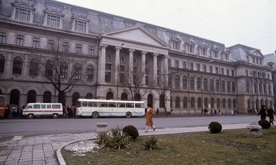
Bulevardul Regina Elisabeta (Bulevardul Gheorghe Gheorghiu-Dej), a Bukaresti Egyetem (Universitatea Bucuresti)
1986 · FORTEPAN / Urbán Tamás · CC BY-SA 3.0


On the old maps
The place appears on 45 maps and images, from 1790 to today:
- 1790 · Specht Plan
- 1791 · Ernst Plan
- 1846 · Borroczyn Plan
- 1852 · Borroczyn Plan
- 1864 · Szathmari Plan
- 1871 · Pappasoglu Plan
- 1883 · Cerkez Plan
- 1893 · Orăscu Plan
- 1896 · J. Don Plan
- 1900 · Plan of Bucharest 1900
- 1911 · Army Geographic Institute Plan
- 1914 · Socec Plan
- 1921 · Mihai Pantea Plan
- 1926 · Union Plan
- 1927 · Aerial photo 1927
- 1927 · Socec Plan
- 1928 · Industrial Plan
- 1931 · STB Plan
- 1931 · Unirea Plan
- 1934 · Wahing Plan
- 1938 · Aerial photo 1938
- 1938 · Teodorescu Plan
- 1939 · Simboteanu and Moldoveanu Plan
- ~1940 · Artillery Firing Plans
- 1943 · Aerial photo 1943
- 1962 · Cadastral Plan (center)
- 1966 · Satellite image 1966
- 1968 · Map of Bucharest 1968
- 1969 · Map of Bucharest 1969
- 1972 · Satellite image 1972
- 1974 · Cadastral Plan (center)
- 1976 · Satellite image 1976
- 1977 · Satellite image 1977
- 1978 · Satellite image 1978
- 1979 · Satellite image 1979
- 1980 · Satellite image 1980
- 1982 · Satellite image 1982
- 1982 · ITB Plan
- 1983 · Satellite image 1983
- 1984 · Satellite image 1984
- ~1985 · Soviet Topographic Map
- 1990 · Cadastral Plan
- 2001 · AGC Polonia Plan
- 2017 · Orthophoto 2017
- today · Current satellite
Nearby
- Statue of Ion Heliade-Rădulescu · 50 m
- St. Sava Monastery (lost) · 60 m
- Suțu Palace · 100 m
- Ion Mincu Institute of Architecture Palace · 110 m
- Statue of Spiru Haret · 120 m
- Enei Church · 140 m