 Altădată
Lost church · 1716–1736; demolată 1986
Văcărești Monastery
The monastery was founded by Prince Nicolae Mavrocordat on Văcărești hill, which overlooked the city from the southeast: work began in 1716 and ended in 1722, and the church, dedicated to the Holy Trinity, was consecrated in 1724. Considered by some historians the crowning achievement of the Brâncovenesc style, it had a Greek school, a printing press and a famous library; in 1736 Constantin Mavrocordat added a chapel and a second precinct. Later turned into a prison, the monastery had been partly restored in the 1970s, but in 1986 Nicolae Ceaușescu ordered its demolition.
See the place on the old maps ›Text source: ro.wikipedia.org · summary based on the source
Old photographs

Biserica Vacaresti
1902 · Public domain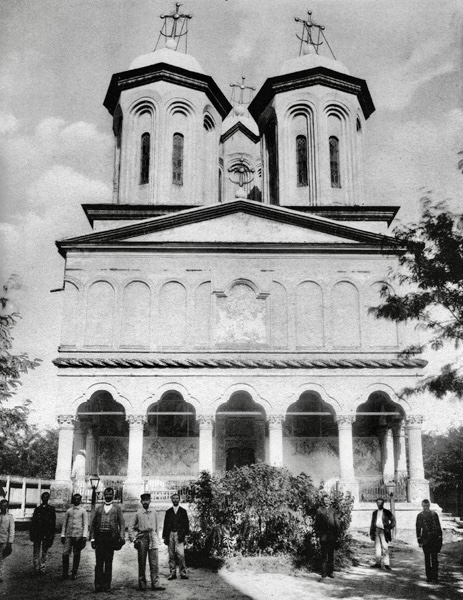
L'Eglise Vacaresti
1902 · Alexandru Antoniu · Public domain
Biserica Manastirii Vacaresti
1906 · Public domain
Foisor la Vacaresti
1906 · Public domain
Interior al Bisericii Vacaresti
1906 · Public domain
Mănăstirea Văcărești ianuarie
1987 · Public domain


On the old maps
The place appears on 36 maps and images, from 1790 to today:
- 1790 · Specht Plan
- 1791 · Ernst Plan
- 1846 · Borroczyn Plan
- 1852 · Borroczyn Plan
- 1864 · Szathmari Plan
- 1871 · Pappasoglu Plan
- 1883 · Cerkez Plan
- 1893 · Orăscu Plan
- 1911 · Army Geographic Institute Plan
- 1921 · Mihai Pantea Plan
- 1926 · Union Plan
- 1928 · Industrial Plan
- 1931 · STB Plan
- 1931 · Unirea Plan
- 1934 · Wahing Plan
- 1938 · Teodorescu Plan
- 1939 · Simboteanu and Moldoveanu Plan
- ~1940 · Artillery Firing Plans
- 1966 · Satellite image 1966
- 1968 · Map of Bucharest 1968
- 1969 · Map of Bucharest 1969
- 1972 · Satellite image 1972
- 1976 · Satellite image 1976
- 1977 · Satellite image 1977
- 1978 · Satellite image 1978
- 1979 · Satellite image 1979
- 1980 · Satellite image 1980
- 1982 · Satellite image 1982
- 1982 · ITB Plan
- 1983 · Satellite image 1983
- 1984 · Satellite image 1984
- ~1985 · Soviet Topographic Map
- 1990 · Cadastral Plan
- 2001 · AGC Polonia Plan
- 2017 · Orthophoto 2017
- today · Current satellite
Nearby
- Foișor Mills · 1660 m
- Vitan Mills · 1870 m
- Cărămidarii de Jos Church · 1970 m
- Foișor Church · 2080 m
- Târca – Vitan Church · 2120 m
- Cenușa Crematorium · 2350 m